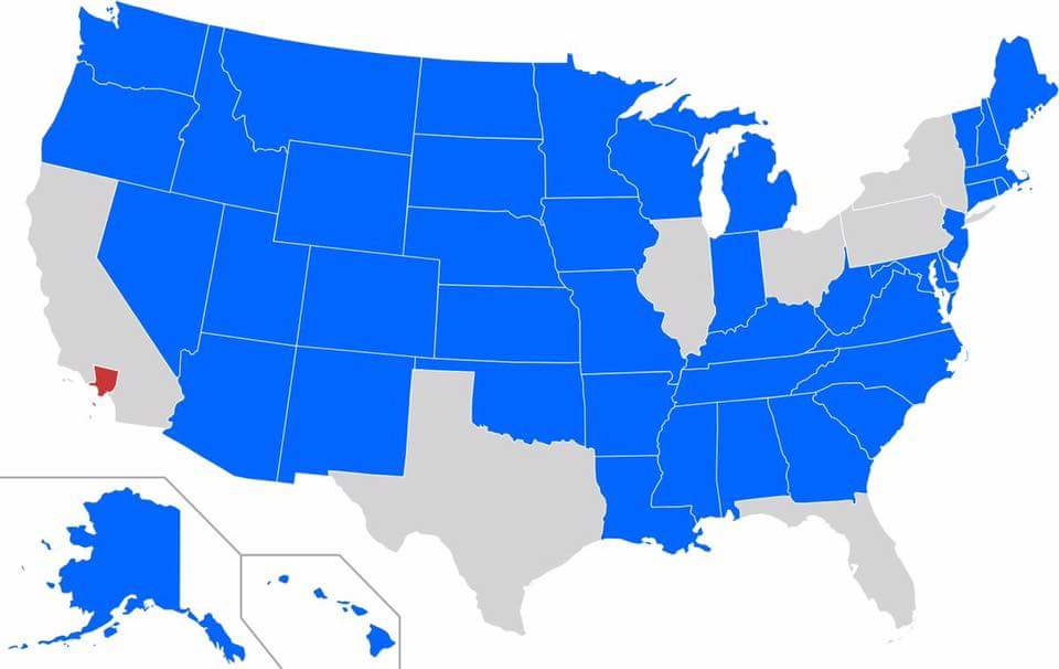
rare ohio victory
Map Enthusiasts
For the map enthused!
Rules:
-
post relevant content: interesting, informative, and/or pretty maps
-
be nice
You know, this would be much more accurately captioned as a map of how a president could win with as little of the popular vote as possible. Lowest possible score is 21%.
Can we talk about the fact that Wyoming shouldn't even be a state based on their miniscule population.
In a global warming world it'll be prime real estate in a couple of generations though
[slaps car] "this thing will hold so many... climate refugees!"
My state is not there. Is this all states or just some of them?
I don't see any missing states. Maybe I'm mistaken but I do believe I see 50 states
The State of Depression is not on there 🤷♂️
LA does not have a bigger population than Georgia, and probably not Michigan and a few others. Map is bs.
Still, a shitload of people in trouble rn
California, Texas, Florida , New York , Pennsylvania, Illinois, Ohio , Georgia, North Carolina, and Michigan are the ten states that aren't less populated than LA county, to save anyone else who's curious from needing to look it up.
Yeah it looks like NJ makes it in by the skin of its teeth and over that the top 10 most populous states all have more people in them than LA County — of which Michigan is one.
2 senators each.
I mean that's why we also have representatives that match the population.
Unfortunately no because in 1929 the House of Representatives got capped at 435. For example, a Congressman from California represented 494,709 people while one from New Hampshire represented 3,448 people in the year 2020.
Maybe time for a Port of Oakland tea party but with... Oh wait.. we don't need imports from the rest of the country and should just stop paying taxes without representation or something
I'm not an advocate of secession under normal circuimstances, what with the looming threat of WWIII if ever the power scale tipped against the USA, but it's especially a bad idea when California is covered in fire.
Even that is capped though, so the smaller states are still vastly overrepresented. Living in LA means your vote is only represented at ~1/100th as much as the least populated areas. Because even the least populated areas still get a representative, but the populated areas are capped on how many they can have.
Every state still gets at least one. Even if the population is 584,000
LA seems to have so much amazing culture but it is drowning in an addiction to cars perhaps worse than almost any other US city and it totally turns me off from going. edit, I didn't mean this as a dig at the average person in LA I literally mean the city itself
I have flown over the endless sprawl and traffic jams on approach to LAX and like vomits in trash can nope. It looks like 1000% the kind of city where it takes at least an hour to get somewhere no matter how close on paper it is.
It is a phenomena of a place, and easily creates and does more to make the world better than all of those rural conservative states combined I just wish it wasn't a car hellscape so I actually desired to visit.
It seems like LA has been making serious progress on becoming more walkable, so I am excited to see where it goes though!
Holy hell the urban sprawl is insane
Just grid for hundreds of miles around
as an expert on the topic of los angeles (i spent 3 days there, many years ago), i can confirm that it is exactly the kind of city where every drive takes 1 hour. if you have to get on the highway to go somewhere, you better cancel your plans for the evening because your new plan is to sit in traffic forever.
It's nothing specific to LA, it's what any city with that population and a car centered infrastructure turns into.
I know that's probably what you meant, just wanted to add a bit o' clarity.
It sure is a good thing that land elects presidents.
Don't forget Senators too!
How else would the slave-owning states have the slavery powers they so needed?!?
Hmm, it's too soon to make the obvious fire joke...
Map is missing a few based on this: https://en.m.wikipedia.org/wiki/Los_Angeles_County,_California
https://en.m.wikipedia.org/wiki/List_of_U.S._states_and_territories_by_population
Maybe it was based off the 2020 census where it had a higher population, but even then it had less than Michigan, so idk where this is coming from.
It's one of the 33 megacities in the world, so it makes sense.
Which population numbers are you using for this graph? Census data for 2020 has LA county at 10.01 million and NC and Georgia at 10.45 and 10.73 million respectively. (for the second link, click on the Table 1 PDF. I didn't want to link to a PDF directly). 2023 numbers seem to have LA county trending down while those states are trending up.
It's still a staggering visual to compare population densities. I just thought the claim was a bit suspect regarding my state.
NC has a higher pop than LA county.
Wake county (NC) has a higher pop than MT.
I lived near Orange for a while. The way the cities and towns have 0 gaps between them was nuts to me. It's just.. you cross the street.
In MT you have 2 lane roads with several miles in between. The county I'm in now doesn't touch the interstate. Wild.
Also means the fires out here, as terrifying as they are to my hurricane-seasoned ass, are more likely to take out stuff in the middle of nowhere and a handful of houses, not entire swaths of suburbia.
