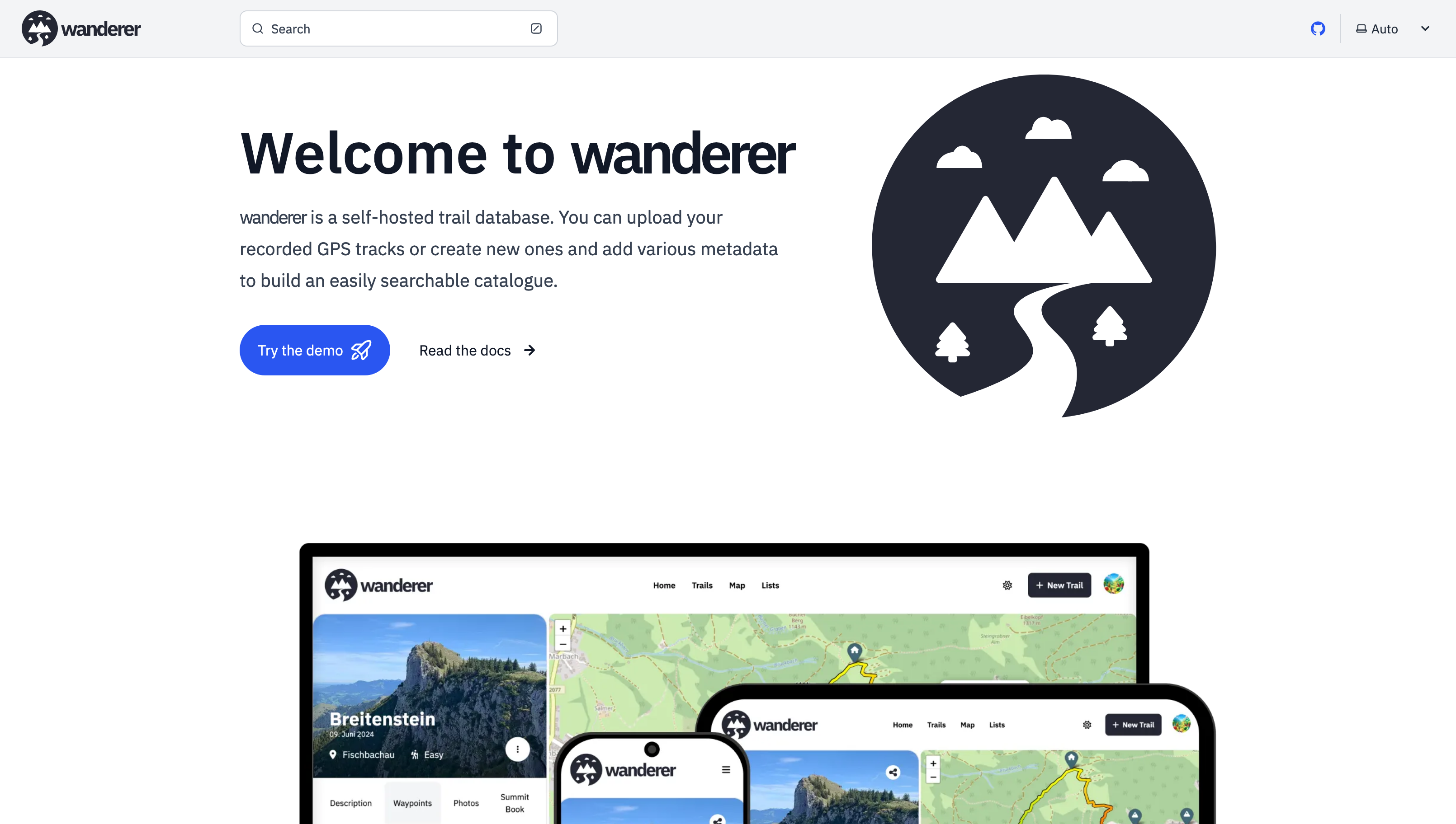
[-] [email protected] 11 points 3 months ago

Cool! I always recommend OsmAnd.

367
submitted 3 months ago* (last edited 3 months ago) by [email protected] to c/[email protected]

Hey there,

it's been a while since my last post. Since then - with the help of this awesome community - I have added multiple new features and fixed a lot of bugs.

Most importantly there is now a working demo alongside a shiny new landing page.

And here are some more fun features I added since then:

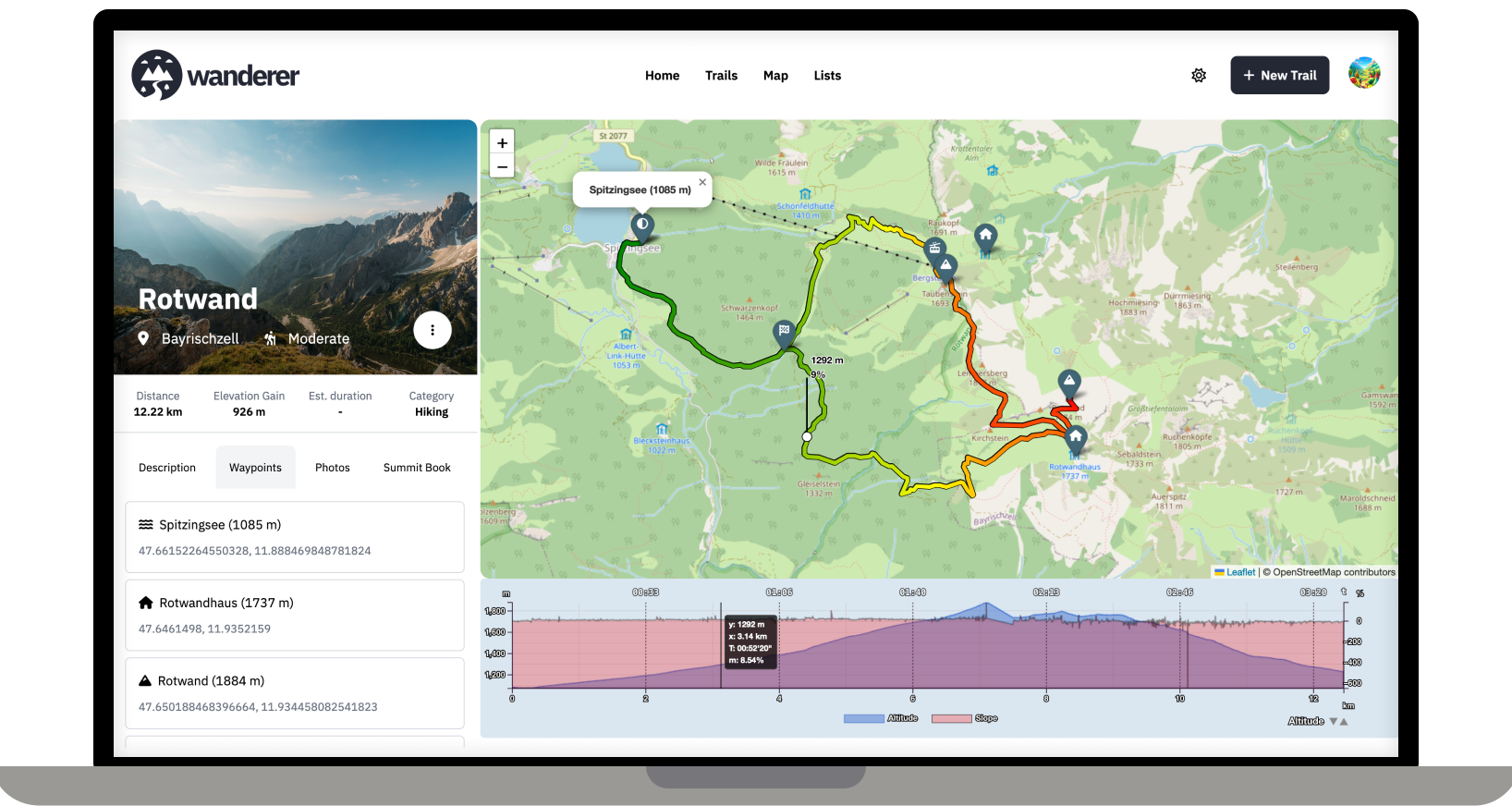
  • Trail drawing: in addition to uploading you GPX, TCX or KML files, you can now also simply draw a trail by defining multiple waypoints. The route between them will be calculated automatically.
  • Sharing trails: simple and straightforward - you can share your trails with other users and let them view or edit.
  • Printing trails: there is now a dedicated print view. Plan your adventure digitally and then take it with you on paper.
  • wanderer is now available in 8 different languages (thanks to translators from the community). If you would like to contribute a translation you can do so here.
  • You can now bulk upload multiple trails at once simply by putting them in a dedicated auto-upload folder

And much more. I'd be happy if you give it a try in case you haven't yet.

GitHub repo: https://github.com/Flomp/wanderer

[-] [email protected] 18 points 5 months ago

With docker you can simply change the port mapping in the compose file

[-] [email protected] 4 points 5 months ago* (last edited 5 months ago)

Absolutely all help is welcome. Please check out the roadmap for my current plans. I'd be delighted if you could add your Dutch translation here: https://translate.codeberg.org/projects/wanderer/wanderer/nl/

Dank je wel!

[-] [email protected] 9 points 5 months ago

Logging trips offline requires background location services. This does not work for a simple website. You would need to program an app for that. While this is a plan somewhere down the line, it's still far away. So currently I would recommend relying on an external app to log your trip and import afterwards.

[-] [email protected] 40 points 5 months ago

I think you might misunderstand what wanderer does. It is not a maps service like Open Street Maps. It's simply a database in which you can store your GPS tracks. So the workflow would look like this: you are in the woods and record your track (e.g. with osmand) -> you store your track in GPX format -> you upload your track (and any additional info like a description or photos) to wanderer -> before your next adventure you check wanderer to decide what you want to do

[-] [email protected] 4 points 5 months ago* (last edited 5 months ago)

Happy to help. If you can get a dump of the database it should be quite easy to import it into wanderer via the API 👍

[-] [email protected] 5 points 5 months ago

Absolutely. I have it running on a Pi 5 and that's more than enough. You only need 1GB of RAM when first starting wanderer. After that it sits at around 100Mb.

[-] [email protected] 5 points 5 months ago

wanderer currently parses distance, elevation gain, duration and speed. Parsing heart rate would be an easy addition, though.

[-] [email protected] 10 points 5 months ago

You can also install it directly on your machine: https://github.com/Flomp/wanderer/wiki/Installation#from-source

It's just much more tedious imo.

[-] [email protected] 5 points 5 months ago

I see. I'm unfamiliar with the protocol, but sharing trails is definitely on the roadmap. So I will look into it!

[-] [email protected] 16 points 5 months ago

Thanks for promoting wanderer! Finding trails on the map should be no problem, you can currently mark trails as public so that not logged-in users can see the trail. I have thought of steering wanderer towards a more socially interactive platform. I think a good first step would be to allow comments and implement a rating system.

Thanks for the crowdsourced translation website. I was looking for something like this. I will set it up and add it to the contributing section of the documentation.

[-] [email protected] 11 points 5 months ago

I'm not sure if I understand your question correctly. Do you mean creating a trail from scratch on the map without recording it before? That is indeed on my roadmap.

920
submitted 5 months ago by [email protected] to c/[email protected]

Over the last two months, I developed wanderer. It is a self-hosted alternative to sites like alltrails.com or in other words a self-hosted trail database. It started out more as a small hobby project to teach myself some new technologies but in the end, I decided to develop it into a fully-fledged application.

Core Features:

  • Manage your trails
  • Extensive map integration and visualization
  • Share trails with other people and explore theirs
  • Advanced filter and search functionality
  • Create custom lists to organize your trails further
  • Chique design with a dark and light theme
  • Fully mobile compatible

wanderer is completely open-source. You can find the GitHub repo here: https://github.com/Flomp/wanderer

wanderer is still under active development so if you encounter any bugs/errors or have suggestions please let me know here or open an issue on GitHub.

view more: next ›

get_flomped

joined 5 months ago