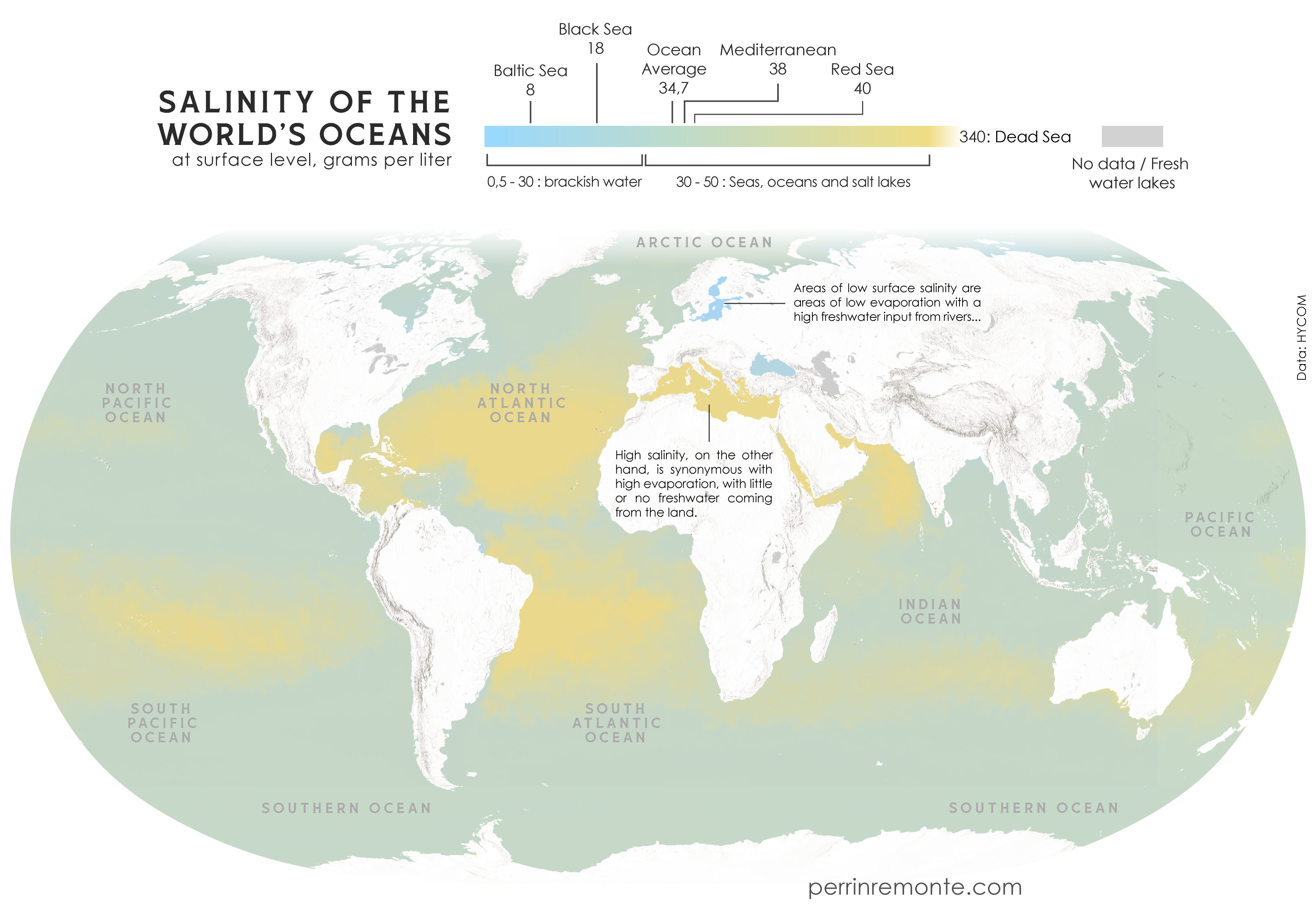
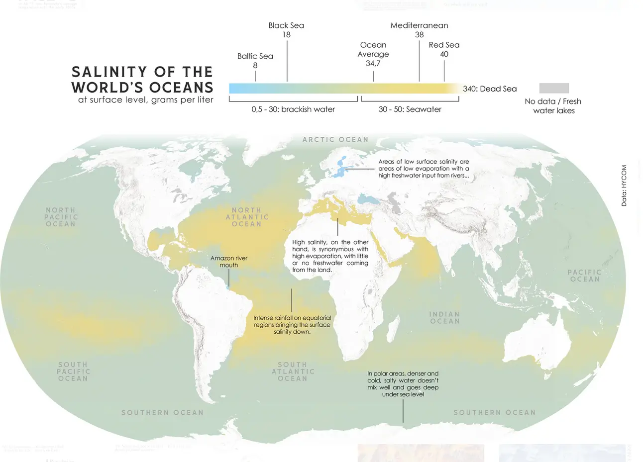
65
submitted 2 weeks ago* (last edited 2 weeks ago) by [email protected] to c/[email protected]
top 12 comments
sorted by: hot top controversial new old
[-] [email protected] 6 points 2 weeks ago

This explains why i float so easily down here in colombia but in maine i sink like a stone.

[-] [email protected] 4 points 2 weeks ago

I'm surprised that the effect of major rivers is big enough to be visible on a global map, at least in otherwise saline areas (Amazon, Mississippi, Congo?). Interestingly, the world's longest river (Nile) which drains into one of the saltiest seas (Mediterranean) doesn't register on this scale at all.

[-] [email protected] 5 points 2 weeks ago

The Nile's average volume is not actually all that big. The Amazon puts more than 70 times as much water into the ocean, apparently. Although the Amazon is quite an outlier in that regard, being about as big as the 2nd through to 7th largest combined

[-] [email protected] 3 points 2 weeks ago

I don’t understand how the Mediterranean shows as mustard on the map while on the scale its marked as green.

[-] [email protected] 7 points 2 weeks ago* (last edited 2 weeks ago)
[-] [email protected] 2 points 2 weeks ago

Cool - i love updates with more sense

[-] [email protected] 4 points 2 weeks ago

I'll never forget the first time I went on holiday to Greece and jumped into the water. Saltiest water I've ever felt, ended up just swimming in the pool instead. Much better water up here in the north, even if it's a bit cold.

[-] [email protected] 2 points 2 weeks ago

Interesting, thanks.

[-] [email protected] 2 points 2 weeks ago

Is thw equatorial concentration from planet spinning and higher density of salt water? Thats cool af

[-] [email protected] 4 points 2 weeks ago

OP has actually posted an update that (indirectly) explains it! https://sopuli.xyz/pictrs/image/f2a9b56e-f915-4932-a35a-d4c3a6e472c9.webp

The equator is actually the less-salty bit in between the two high-salt bands. You'll see the note that says that the less saline areas around the equator are the tropical latitudes that get a lot of rainfall. Because the equator is the most consistently-warm latitude, a lot of water evaporates there and is carried upwards, then falls back down as rain. That air can't keep going up forever though, so it spills out to the north and south. By this point the water has fallen out of it and it has cooled, so it sinks back down and creates dry areas either side of the equator. We can see this as the two yellow bands on the map, and you'll notice that the land in line with those is where we see deserts like the Sahara, the Kalahari, Arabian desert, and central Australia. And also lots of salt at the surface of the ocean, apparently, because there's no rain falling on it.

[-] [email protected] 1 points 2 weeks ago

Makes sense cool that we know this as well.

[-] [email protected] 2 points 2 weeks ago

I think part of the gulf of California is the saltiest on earth

this post was submitted on 11 Sep 2024
65 points (100.0% liked)

Map Enthusiasts

3386 readers
38 users here now

For the map enthused!

Rules:

founded 1 year ago
MODERATORS